So after skipping the 2010 year without bagging a peak, thanks to Ed moving from Portland to D.C. then back to S.L.C. (not to mention someone else who had to relocate from Las Vegas to Denver), we finally found some time to meet up and knock out a big one: Mt. Elbert, Colorado.
Mt. Elbert, Colorado is located near Leadville, Colorado (the highest incorporated town in the U.S.) in Lake County. The peak stands at approximately 14,440 feet above sea level and is the 2nd highest peak within the 48 contiguous states and only about 50 feet shorter than Mt. Whitney in California.
August 4, 2011
The group flew in from Phoenix, Las Vegas, and S.LC. and they arrived at Denver airport on Thursday night starting with Shaun at 8:00pm, Ed around 10:00pm, and finally Shan after midnight. Unfortunately for Shan his flight was delayed two hours, and he was originally supposed to arrive around 10:20pm, shortly after Ed. Once the group was gathered, we stopped by Denny's on the way home to grab a late dinner, and we finally made it to Castle Rock around 3:30am. Tanna wasn't too happy to see us show up so late, but she knew Shan had been delayed.
August 5, 2011
The following morning, we gathered everything up, stopped by the grocery store to grab some food, and hit the road around 2:30pm. I decided to take the longer, more scenic route on I-285 and going through Buena Vista instead of driving up the I-70 and going through Leadville. The drive was nice, but it did take about 3 hours to get to the campsite. I reserved a camping spot in Lakeview campground near the Twin Lakes area, which was very nice and close to the South Elbert Trail Head. I had read that that the South Elbert Trail was more gradual in its ascent but a little longer than the North Halfmoon Trail, and it was recommended by the locals. The campground was excellent. It had a picnic table, grill, running water, a very clean outhouse, and enough privacy from the next site. (I'm glad I reserved the spot online because we saw many prospective campers drive around the loop looking for a vacant camp site, but all were reserved.) After setting up the tent, we cooked some BBQ shortribs and potatoes in my two little 10" dutch ovens, relaxed around the campsite, and enjoyed the mild 72-degree temps. We were diligent in cleaning up the campsite before going to bed since the ranger told us there was a black bear warning in our area.
August 6, 2011
The South Elbert Trail Head was about a 20-minute drive from the campsite. I passed up the initial trail head marker and put my truck in low 4x4, crawled up a semi-rough, single lane road to a 2nd trail head, which saved us about 2 miles and 1,000'. This trail head was definitely popular, and it was hard to find a parking spot, but we managed and finally hit the trail around 8:30am.
 |
| The trail is calling. 8:30am. |
 |
| A little over 1,000 ft. per mile. |
 |
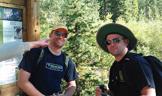
Ed had to stop and buy a cowboy hat and aviation
glasses. The neckerchief was the final touch. |
 |
| Shaun was feeling the effects of the high altitude early on. |
 |
| There were lots of wildflowers in bloom. |
 |
Mt. Elbert is in the upper left.
It doesn't look too bad from here. |
 |
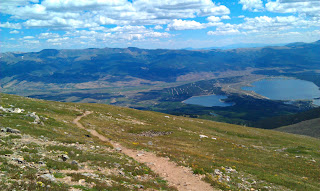
| About 12,000 ft. Twin Lakes in background. |
 |
| Ed was capturing some video on his new HTC Thunderbolt. |
 |
| Ed wandered off to get some more footage. |
 |
| Another view of the peak. |
 |
I definitely recommend a hat and glasses.
The sun is intense up here! |
 |
| Shan and Shaun bringing up the rear. |
 |
| Ed leaves us in the dust after this. |
 |
| Maybe another 1,000 ft. to climb. |
 |
| I kept using this neighboring peak as a reference. |
 |
| Almost there. |
 |
| SUMMIT |
 |
| Ed had arrived earlier at 12:35pm. |
 |
| I summitted at 1:05pm. |
 |
| Lol, not exactly the same pose as in King's Peak. |
 |
| I don't see any peaks higher than me. |
 |
Time to relax and refuel.
Shan and Shaun show up shortly. |
 |
| I had to look for the marker. It wasn't at the very top. |
 |
| Shan and Shaun summit at 1:35pm. |
 |
| We couldn't have had better weather. |
 |
| The descent was quick. Hello blisters! |
 |
| More wildflowers near the end of the trail. |
 |
| Elevation profile from my Garmin GPS 60CSx. |
 |
| 4.3 miles one way according to GPS. |
 |
I invited the family to join us in camp when I was on the
summit. The kids' first camp out! |
 |
| Lakeview Campground. |
 |
The kids were really excited! Tanna was nice
enough to bring us some more food too :-) |
 |
| Matthew's first time roasting marshmallows. |


